Flood risk mapping identifies areas prone to inundation based on historical data and topography, essential for property insurance assessments and disaster preparedness. Storm surge modeling predicts coastal water level rises during hurricanes by simulating atmospheric pressure, wind, and tide interactions, critical for mitigating hurricane-related insurance claims. Explore these advanced techniques to enhance your understanding of flood and storm surge impacts on insurance risk management.
Why it is important
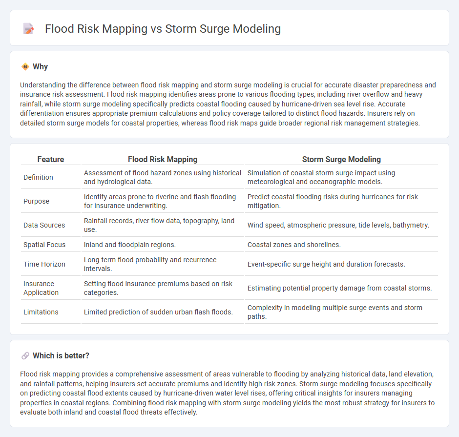
Understanding the difference between flood risk mapping and storm surge modeling is crucial for accurate disaster preparedness and insurance risk assessment. Flood risk mapping identifies areas prone to various flooding types, including river overflow and heavy rainfall, while storm surge modeling specifically predicts coastal flooding caused by hurricane-driven sea level rise. Accurate differentiation ensures appropriate premium calculations and policy coverage tailored to distinct flood hazards. Insurers rely on detailed storm surge models for coastal properties, whereas flood risk maps guide broader regional risk management strategies.
Comparison Table
| Feature | Flood Risk Mapping | Storm Surge Modeling |
|---|---|---|
| Definition | Assessment of flood hazard zones using historical and hydrological data. | Simulation of coastal storm surge impact using meteorological and oceanographic models. |
| Purpose | Identify areas prone to riverine and flash flooding for insurance underwriting. | Predict coastal flooding risks during hurricanes for risk mitigation. |
| Data Sources | Rainfall records, river flow data, topography, land use. | Wind speed, atmospheric pressure, tide levels, bathymetry. |
| Spatial Focus | Inland and floodplain regions. | Coastal zones and shorelines. |
| Time Horizon | Long-term flood probability and recurrence intervals. | Event-specific surge height and duration forecasts. |
| Insurance Application | Setting flood insurance premiums based on risk categories. | Estimating potential property damage from coastal storms. |
| Limitations | Limited prediction of sudden urban flash floods. | Complexity in modeling multiple surge events and storm paths. |
Which is better?
Flood risk mapping provides a comprehensive assessment of areas vulnerable to flooding by analyzing historical data, land elevation, and rainfall patterns, helping insurers set accurate premiums and identify high-risk zones. Storm surge modeling focuses specifically on predicting coastal flood extents caused by hurricane-driven water level rises, offering critical insights for insurers managing properties in coastal regions. Combining flood risk mapping with storm surge modeling yields the most robust strategy for insurers to evaluate both inland and coastal flood threats effectively.
Connection
Flood risk mapping relies heavily on storm surge modeling to predict the extent and depth of water intrusion during coastal weather events, enhancing insurance risk assessments. Accurate storm surge models simulate potential flooding scenarios based on wind speed, atmospheric pressure, and topography, directly informing flood zone delineations crucial for underwriting. Integrating these techniques enables insurers to set more precise premium rates and develop targeted mitigation strategies for properties vulnerable to flood damage.
Key Terms
Hazard Assessment
Storm surge modeling simulates the rise in seawater levels caused by storm events, integrating factors like wind speed, atmospheric pressure, and tidal conditions to predict inundation extents. Flood risk mapping incorporates storm surge outputs with topographical data and population exposure to assess hazard zones and potential impacts on infrastructure and communities. Explore detailed methodologies and applications in hazard assessment for comprehensive coastal risk management.
Exposure Data
Storm surge modeling relies heavily on high-resolution hydrodynamic data and coastal topography to predict water levels during extreme weather events, accurately assessing the extent and timing of surges. Flood risk mapping integrates exposure data such as population density, infrastructure, land use, and socioeconomic factors to evaluate vulnerability and potential damage from flooding scenarios. Explore detailed methodologies and case studies to understand the critical role of exposure data in enhancing flood risk management.
Vulnerability Analysis
Storm surge modeling simulates coastal water level rises caused by extreme weather events, providing critical data on potential inundation areas and wave impacts essential for assessing exposure. Flood risk mapping integrates hazard data from storm surge models with socioeconomic factors to identify vulnerable populations, infrastructure, and land use patterns subject to flood damage. Explore comprehensive approaches to vulnerability analysis by understanding how storm surge modeling enhances flood risk mapping accuracy and resilience planning.
Source and External Links
Numerical Models of Storm Surge, Wave, and Coastal Flooding - Storm surge models predict real-time surge and future flooding risk, typically using two-dimensional models like SLOSH, ADCIRC, and CH3D-SMSS for accurate water level rise estimations during storms.
Development of a novel storm surge inundation model framework for ... - A new storm surge inundation model incorporates a wetting and drying algorithm with cellular automata to improve computational efficiency and accuracy for flood disaster prevention.
Storm Surge | Sea Level Rise - StormSmart Connect - ADCIRC is a widely used, physics-based storm surge model for coastal circulation and flooding used by USACE and FEMA, often coupled with wave models like UnSWAN for enhanced storm surge analysis.