Flood risk mapping analyzes terrain, rainfall patterns, and water flow to identify areas prone to flooding, aiding insurers in evaluating potential claim costs and setting premiums. Earthquake hazard assessment evaluates seismic activity, fault lines, and ground shaking probabilities to estimate risk levels and inform insurance coverage for structural damage. Explore how these methodologies impact risk management and resilience planning in the insurance industry.
Why it is important
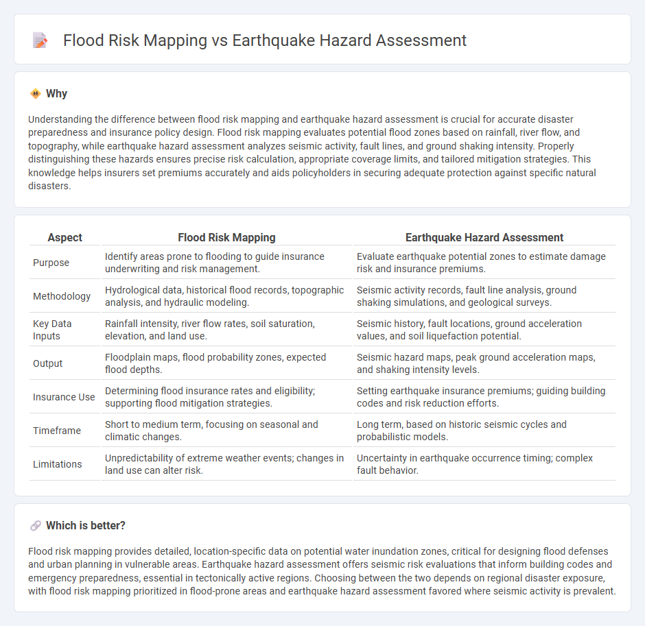
Understanding the difference between flood risk mapping and earthquake hazard assessment is crucial for accurate disaster preparedness and insurance policy design. Flood risk mapping evaluates potential flood zones based on rainfall, river flow, and topography, while earthquake hazard assessment analyzes seismic activity, fault lines, and ground shaking intensity. Properly distinguishing these hazards ensures precise risk calculation, appropriate coverage limits, and tailored mitigation strategies. This knowledge helps insurers set premiums accurately and aids policyholders in securing adequate protection against specific natural disasters.
Comparison Table
| Aspect | Flood Risk Mapping | Earthquake Hazard Assessment |
|---|---|---|
| Purpose | Identify areas prone to flooding to guide insurance underwriting and risk management. | Evaluate earthquake potential zones to estimate damage risk and insurance premiums. |
| Methodology | Hydrological data, historical flood records, topographic analysis, and hydraulic modeling. | Seismic activity records, fault line analysis, ground shaking simulations, and geological surveys. |
| Key Data Inputs | Rainfall intensity, river flow rates, soil saturation, elevation, and land use. | Seismic history, fault locations, ground acceleration values, and soil liquefaction potential. |
| Output | Floodplain maps, flood probability zones, expected flood depths. | Seismic hazard maps, peak ground acceleration maps, and shaking intensity levels. |
| Insurance Use | Determining flood insurance rates and eligibility; supporting flood mitigation strategies. | Setting earthquake insurance premiums; guiding building codes and risk reduction efforts. |
| Timeframe | Short to medium term, focusing on seasonal and climatic changes. | Long term, based on historic seismic cycles and probabilistic models. |
| Limitations | Unpredictability of extreme weather events; changes in land use can alter risk. | Uncertainty in earthquake occurrence timing; complex fault behavior. |
Which is better?
Flood risk mapping provides detailed, location-specific data on potential water inundation zones, critical for designing flood defenses and urban planning in vulnerable areas. Earthquake hazard assessment offers seismic risk evaluations that inform building codes and emergency preparedness, essential in tectonically active regions. Choosing between the two depends on regional disaster exposure, with flood risk mapping prioritized in flood-prone areas and earthquake hazard assessment favored where seismic activity is prevalent.
Connection
Flood risk mapping and earthquake hazard assessment are interconnected through their reliance on geospatial data and environmental modeling to predict natural disaster impacts. Both methods utilize topographic, soil, and infrastructure information to evaluate vulnerability and inform insurance risk pricing accurately. Integrating these assessments enables insurers to develop comprehensive coverage strategies that address compound risks in disaster-prone regions.
Key Terms
**Earthquake hazard assessment:**
Earthquake hazard assessment involves evaluating the likelihood and intensity of seismic events based on historical data, fault line analysis, and ground motion modeling. This process integrates geological surveys, seismic monitoring, and probabilistic seismic hazard analysis (PSHA) to predict potential earthquake impacts on infrastructure and communities. Explore detailed methodologies and latest advances in earthquake hazard assessment to enhance seismic risk mitigation strategies.
Seismic hazard zones
Seismic hazard zones identify regions prone to earthquakes by analyzing fault lines, ground shaking potential, and historical seismic activity, essential for earthquake hazard assessment. In contrast, flood risk mapping evaluates areas susceptible to flooding through hydrological data, rainfall patterns, and topography. Discover detailed methodologies and applications of seismic hazard zones for enhanced disaster preparedness.
Peak ground acceleration
Peak ground acceleration (PGA) is a crucial parameter in earthquake hazard assessment, representing the maximum ground shaking intensity during seismic events and directly influencing structural design and safety standards. In contrast, flood risk mapping prioritizes hydrological data such as water depth, velocity, and inundation frequency, with minimal consideration of PGA, since seismic ground shaking does not significantly impact flood dynamics. Explore the distinctive methodologies and critical parameters used in both earthquake hazard assessment and flood risk mapping for comprehensive disaster risk management.
Source and External Links
Earthquake Hazard and Risk Assessment - PreventionWeb - Earthquake hazard assessment calculates the likelihood of ground shaking in a region using data like earthquake catalogues and active faults, with methods including deterministic and probabilistic approaches essential for risk mapping and design codes.
Seismic Hazard Assessment Guide - Number Analytics - Seismic hazard assessment employs probabilistic and deterministic methods to evaluate earthquake risks, involving hazard mapping, vulnerability assessment, and the use of GIS and specialized software for risk mitigation planning.
What is earthquake risk? - EFEHR - Earthquake hazard assessment integrates historical data, geology, and local soil conditions to estimate shaking potential, which combined with building exposure and vulnerability, supports seismic risk estimation and effective mitigation strategies.