Alternative data analytics harnesses non-traditional data sources such as social media trends, transactional data, and web traffic to provide unique investment insights beyond conventional financial reports. Satellite imagery offers a distinct advantage by delivering real-time visual data on physical assets, supply chains, and environmental changes, enabling more precise market predictions. Explore how combining these innovative tools can transform your investment strategies.
Why it is important
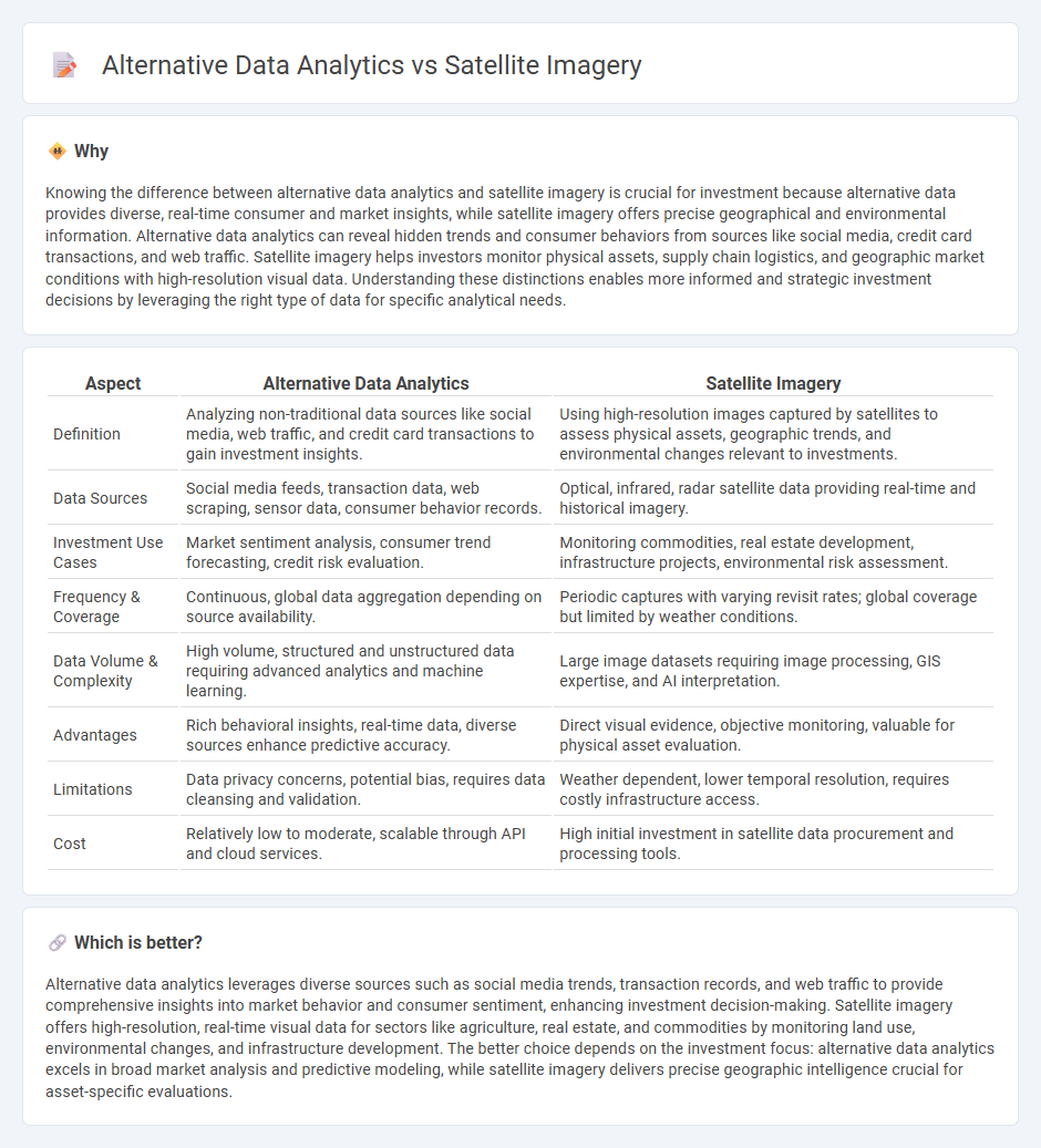
Knowing the difference between alternative data analytics and satellite imagery is crucial for investment because alternative data provides diverse, real-time consumer and market insights, while satellite imagery offers precise geographical and environmental information. Alternative data analytics can reveal hidden trends and consumer behaviors from sources like social media, credit card transactions, and web traffic. Satellite imagery helps investors monitor physical assets, supply chain logistics, and geographic market conditions with high-resolution visual data. Understanding these distinctions enables more informed and strategic investment decisions by leveraging the right type of data for specific analytical needs.
Comparison Table
| Aspect | Alternative Data Analytics | Satellite Imagery |
|---|---|---|
| Definition | Analyzing non-traditional data sources like social media, web traffic, and credit card transactions to gain investment insights. | Using high-resolution images captured by satellites to assess physical assets, geographic trends, and environmental changes relevant to investments. |
| Data Sources | Social media feeds, transaction data, web scraping, sensor data, consumer behavior records. | Optical, infrared, radar satellite data providing real-time and historical imagery. |
| Investment Use Cases | Market sentiment analysis, consumer trend forecasting, credit risk evaluation. | Monitoring commodities, real estate development, infrastructure projects, environmental risk assessment. |
| Frequency & Coverage | Continuous, global data aggregation depending on source availability. | Periodic captures with varying revisit rates; global coverage but limited by weather conditions. |
| Data Volume & Complexity | High volume, structured and unstructured data requiring advanced analytics and machine learning. | Large image datasets requiring image processing, GIS expertise, and AI interpretation. |
| Advantages | Rich behavioral insights, real-time data, diverse sources enhance predictive accuracy. | Direct visual evidence, objective monitoring, valuable for physical asset evaluation. |
| Limitations | Data privacy concerns, potential bias, requires data cleansing and validation. | Weather dependent, lower temporal resolution, requires costly infrastructure access. |
| Cost | Relatively low to moderate, scalable through API and cloud services. | High initial investment in satellite data procurement and processing tools. |
Which is better?
Alternative data analytics leverages diverse sources such as social media trends, transaction records, and web traffic to provide comprehensive insights into market behavior and consumer sentiment, enhancing investment decision-making. Satellite imagery offers high-resolution, real-time visual data for sectors like agriculture, real estate, and commodities by monitoring land use, environmental changes, and infrastructure development. The better choice depends on the investment focus: alternative data analytics excels in broad market analysis and predictive modeling, while satellite imagery delivers precise geographic intelligence crucial for asset-specific evaluations.
Connection
Alternative data analytics integrates satellite imagery to provide real-time insights into market trends, asset performance, and environmental changes. Investors utilize high-resolution satellite images to monitor supply chain activities, track crop health, and assess infrastructure developments, enhancing predictive accuracy. This fusion of alternative datasets enables more informed investment decisions by unveiling hidden patterns not captured in traditional financial reports.
Key Terms
Geospatial Analysis
Satellite imagery provides comprehensive geospatial data by capturing high-resolution images of Earth's surface, enabling precise monitoring of land use, environmental changes, and urban development. Alternative data analytics integrates diverse datasets such as social media, mobile location data, and sensor outputs to enhance geospatial analysis with real-time insights and behavioral context. Explore the advantages of combining satellite imagery and alternative data for more robust geospatial analytics.
Data Integration
Satellite imagery provides extensive geospatial data capturing real-time environmental changes, while alternative data analytics integrates diverse datasets such as social media, mobile GPS, and IoT sensors to enhance contextual understanding. Data integration techniques enable combining satellite imagery with alternative data sources, improving accuracy, predictive modeling, and actionable insights across sectors like agriculture, urban planning, and finance. Explore advanced data integration strategies to maximize the power of combined satellite and alternative data analytics for transformative decision-making.
Alpha Generation
Satellite imagery offers precise, real-time insights into environmental changes, supply chain disruptions, and agricultural health, enhancing alpha generation in investment strategies. Alternative data analytics integrates diverse sources like credit card transactions and social media trends to identify market opportunities ahead of traditional financial metrics. Explore deeper to understand how combining these data streams can refine predictive models and boost alpha generation.
Source and External Links
Satellite Imagery - This Wikipedia page provides an overview of satellite imagery, including its history, applications, and various providers of satellite images.
Free Satellite Imagery: Data Providers & Sources - This blog post discusses free satellite imagery sources, including the Copernicus Data Space Ecosystem, which offers free access to Sentinel data and tools.
Latest Satellite Imagery - NOAA - NOAA provides real-time satellite imagery updates, particularly for hurricane and storm tracking, through its GOES-E and other satellite systems.