Alternative data analytics leverages unconventional data sources such as social media activity, transaction records, and sensor data to uncover hidden investment insights beyond traditional financial metrics. Geospatial analytics utilizes location-based data, satellite imagery, and geographic information systems (GIS) to assess market trends, asset performance, and environmental risks influencing investments. Explore the advantages and applications of these cutting-edge investment tools to enhance portfolio decision-making.
Why it is important
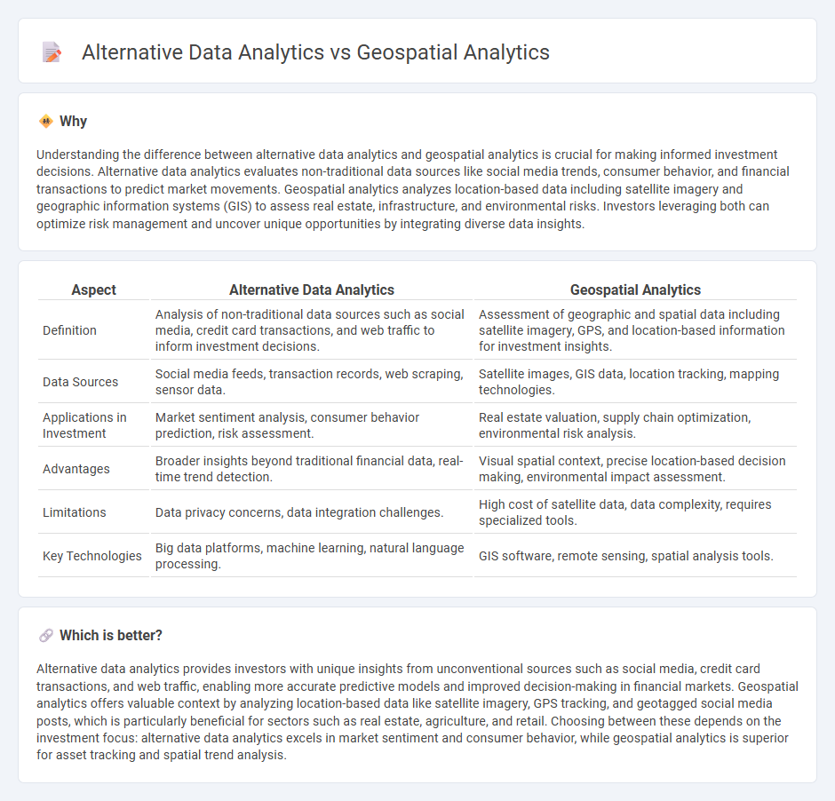
Understanding the difference between alternative data analytics and geospatial analytics is crucial for making informed investment decisions. Alternative data analytics evaluates non-traditional data sources like social media trends, consumer behavior, and financial transactions to predict market movements. Geospatial analytics analyzes location-based data including satellite imagery and geographic information systems (GIS) to assess real estate, infrastructure, and environmental risks. Investors leveraging both can optimize risk management and uncover unique opportunities by integrating diverse data insights.
Comparison Table
| Aspect | Alternative Data Analytics | Geospatial Analytics |
|---|---|---|
| Definition | Analysis of non-traditional data sources such as social media, credit card transactions, and web traffic to inform investment decisions. | Assessment of geographic and spatial data including satellite imagery, GPS, and location-based information for investment insights. |
| Data Sources | Social media feeds, transaction records, web scraping, sensor data. | Satellite images, GIS data, location tracking, mapping technologies. |
| Applications in Investment | Market sentiment analysis, consumer behavior prediction, risk assessment. | Real estate valuation, supply chain optimization, environmental risk analysis. |
| Advantages | Broader insights beyond traditional financial data, real-time trend detection. | Visual spatial context, precise location-based decision making, environmental impact assessment. |
| Limitations | Data privacy concerns, data integration challenges. | High cost of satellite data, data complexity, requires specialized tools. |
| Key Technologies | Big data platforms, machine learning, natural language processing. | GIS software, remote sensing, spatial analysis tools. |
Which is better?
Alternative data analytics provides investors with unique insights from unconventional sources such as social media, credit card transactions, and web traffic, enabling more accurate predictive models and improved decision-making in financial markets. Geospatial analytics offers valuable context by analyzing location-based data like satellite imagery, GPS tracking, and geotagged social media posts, which is particularly beneficial for sectors such as real estate, agriculture, and retail. Choosing between these depends on the investment focus: alternative data analytics excels in market sentiment and consumer behavior, while geospatial analytics is superior for asset tracking and spatial trend analysis.
Connection
Alternative data analytics leverages non-traditional data sources such as satellite images, social media activity, and transaction records to provide deeper investment insights. Geospatial analytics enhances this process by analyzing location-based data from satellites, GPS, and mapping tools to uncover patterns in real estate, agriculture, and retail sectors. Combining these approaches enables investors to identify market trends, assess risks, and make data-driven decisions with higher precision.
Key Terms
**Geospatial analytics:**
Geospatial analytics involves the collection, visualization, and interpretation of data related to geographic locations, leveraging satellite imagery, GPS data, and spatial statistics to uncover patterns and trends. This approach enhances decision-making in sectors like urban planning, environmental monitoring, and logistics by providing insights into spatial relationships and geographic context. Explore more to understand how geospatial analytics drives innovation across industries.
Satellite imagery
Geospatial analytics leverages satellite imagery to extract location-based insights, analyzing spatial patterns, land use, and environmental changes with high precision. Alternative data analytics incorporates diverse unstructured data sources including satellite imagery, social media, and sensor outputs to uncover market trends and behavioral insights beyond traditional datasets. Explore the transformative potential of satellite imagery in both geospatial and alternative data analytics to enhance decision-making processes.
Location intelligence
Geospatial analytics leverages satellite data, GPS coordinates, and geographic information systems (GIS) to extract location-based insights, enhancing decision-making in urban planning, environmental monitoring, and logistics. Alternative data analytics incorporates unconventional datasets such as social media feeds, sensor data, and transaction records to provide a broader context but may lack the precise spatial dimension offered by geospatial tools. Explore in-depth how location intelligence distinguishes geospatial analytics from alternative data techniques to optimize spatial decision-making.
Source and External Links
What is Geospatial Data? | IBM - Geospatial analytics adds location and timing to traditional data, enabling advanced visualizations and trend analysis for better decision making across enterprises.
Geospatial Analytics Market Size, Share | Global Report [2032] - The global geospatial analytics market is rapidly expanding, driven by urbanization, IoT, AI, and government adoption, with applications ranging from supply chain optimization to pandemic response.
Geospatial Analytics Market Size, Share and Industry Report - Machine learning and advanced analytics are transforming geospatial data processing, offering faster, more precise insights for sectors like agriculture, urban development, and disaster management.