Flood risk mapping utilizes hydrological and meteorological data to predict areas vulnerable to river overflow and heavy rainfall-induced flooding, focusing on varying water depths and flow velocities. Tsunami inundation mapping relies on seismic activity and oceanographic models to identify coastlines at risk of tsunami surge, emphasizing wave heights and inundation distances. Explore more to understand how these mapping techniques enhance insurance risk assessment and disaster preparedness.
Why it is important
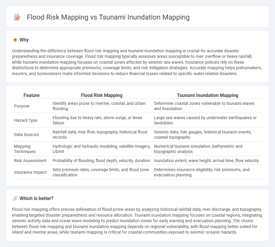
Understanding the difference between flood risk mapping and tsunami inundation mapping is crucial for accurate disaster preparedness and insurance coverage. Flood risk mapping typically assesses areas susceptible to river overflow or heavy rainfall, while tsunami inundation mapping focuses on coastal zones affected by seismic sea waves. Insurance policies rely on these distinctions to determine appropriate premiums, coverage limits, and risk mitigation strategies. Accurate mapping helps policymakers, insurers, and homeowners make informed decisions to reduce financial losses related to specific water-related disasters.
Comparison Table
| Feature | Flood Risk Mapping | Tsunami Inundation Mapping |
|---|---|---|
| Purpose | Identify areas prone to riverine, coastal, and urban flooding | Determine coastal zones vulnerable to tsunami waves and inundation |
| Hazard Type | Flooding due to heavy rain, storm surge, or levee failure | Large sea waves caused by underwater earthquakes or landslides |
| Data Sources | Rainfall data, river flow, topography, historical flood records | Seismic data, tide gauges, historical tsunami events, coastal topography |
| Mapping Techniques | Hydrologic and hydraulic modeling, satellite imagery, LiDAR | Numerical tsunami simulation, bathymetric and topographic analysis |
| Risk Assessment | Probability of flooding, flood depth, velocity, duration | Inundation extent, wave height, arrival time, flow velocity |
| Insurance Impact | Sets premium rates, coverage limits, and flood zone classification | Determines insurance eligibility, risk premiums, and evacuation planning |
Which is better?
Flood risk mapping offers precise delineation of flood-prone areas by analyzing historical rainfall data, river discharge, and topography, enabling targeted disaster preparedness and resource allocation. Tsunami inundation mapping focuses on coastal regions, integrating seismic activity data and ocean wave modeling to predict inundation zones for early warning and evacuation planning. The choice between flood risk mapping and tsunami inundation mapping depends on regional vulnerability, with flood mapping better suited for inland and riverine areas, while tsunami mapping is critical for coastal communities exposed to seismic oceanic hazards.
Connection
Flood risk mapping and tsunami inundation mapping both utilize hydrological and geographical data to identify vulnerable areas prone to water-related disasters, enhancing insurance risk assessment accuracy. These mapping techniques integrate satellite imagery, elevation models, and historical event data to predict flood extents and tsunami impact zones, aiding insurers in calculating premiums and underwriting policies. The combined analysis of flood and tsunami hazards supports more comprehensive disaster risk management and tailored insurance coverage for coastal and floodplain properties.
Key Terms
Hazard Zonation
Tsunami inundation mapping identifies areas at risk from tsunami waves, highlighting coastal zones susceptible to rapid flooding and wave impact, crucial for emergency response and evacuation planning. Flood risk mapping evaluates broader watersheds, considering river overflow, rainfall runoff, and urban drainage to delineate zones prone to riverine and flash floods, informing long-term land use and infrastructure development. Explore detailed methodologies and applications of both mapping techniques for enhanced hazard zonation strategies.
Vulnerability Assessment
Tsunami inundation mapping identifies areas susceptible to sea wave surges caused by seismic activity, emphasizing coastal vulnerability to rapid-onset disasters, while flood risk mapping assesses potential inland and urban flooding from heavy rainfall or river overflow, focusing on prolonged water exposure. Vulnerability assessment in tsunami mapping prioritizes evacuation routes, structural resilience, and community awareness, whereas flood risk assessment integrates drainage capacity, land use, and socio-economic factors to mitigate health and property impacts. Explore detailed methodologies and case studies to deepen your understanding of vulnerability assessment in both tsunami and flood risk mapping.
Loss Estimation
Tsunami inundation mapping provides a detailed spatial representation of areas affected by tsunami waves, focusing on wave height, flow velocity, and inundation extent to estimate potential loss of life and infrastructure damage. Flood risk mapping evaluates the probability and impact of various flooding events, incorporating rainfall, river discharge, and drainage capacity to estimate economic and social losses in vulnerable regions. Explore comprehensive methodologies and case studies to understand how these mapping techniques improve disaster loss estimation and mitigation strategies.
Source and External Links
NOAA Center for Tsunami Research - Inundation Mapping - This webpage provides detailed maps of future tsunami flooding and information on modeling tsunami evolution using the MOST model for evacuation planning and coastal management.
DOGAMI Tsunami Inundation Map (TIM) Series - This series offers systematic, modeled tsunami inundation zones for the Oregon coast, serving as a basis for evacuation brochures and signage.
Tsunami Inundation Mapping - This webpage discusses the publication of tsunami inundation maps in Alaska using numerical modeling to help mitigate tsunami hazards in coastal communities.