Flood risk modeling relies on hydrological data and topographical analysis to assess flood probabilities and potential damage across vulnerable regions. Tornado risk modeling focuses on atmospheric conditions, historical storm paths, and radar data to predict tornado occurrence and intensity within tornado-prone areas. Discover more about how these modeling techniques enhance risk assessment and insurance strategies.
Why it is important
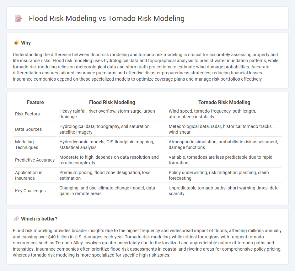
Understanding the difference between flood risk modeling and tornado risk modeling is crucial for accurately assessing property and life insurance risks. Flood risk modeling uses hydrological data and topographical analysis to predict water inundation patterns, while tornado risk modeling relies on meteorological data and storm path projections to estimate wind damage probabilities. Accurate differentiation ensures tailored insurance premiums and effective disaster preparedness strategies, reducing financial losses. Insurance companies depend on these specialized models to optimize coverage plans and manage risk portfolios effectively.
Comparison Table
| Feature | Flood Risk Modeling | Tornado Risk Modeling |
|---|---|---|
| Risk Factors | Heavy rainfall, river overflow, storm surge, urban drainage | Wind speed, tornado frequency, path length, atmospheric instability |
| Data Sources | Hydrological data, topography, soil saturation, satellite imagery | Meteorological data, radar, historical tornado tracks, wind shear |
| Modeling Techniques | Hydrodynamic models, GIS floodplain mapping, statistical analysis | Atmospheric simulation, probabilistic risk assessment, damage functions |
| Predictive Accuracy | Moderate to high, depends on data resolution and terrain complexity | Variable, tornadoes are less predictable due to rapid formation |
| Application in Insurance | Premium pricing, flood zone designation, loss estimation | Policy underwriting, risk mitigation planning, claim forecasting |
| Key Challenges | Changing land use, climate change impact, data gaps in remote areas | Unpredictable tornado paths, short warning times, data scarcity |
Which is better?
Flood risk modeling provides broader insights due to the higher frequency and widespread impact of floods, affecting millions annually and causing over $40 billion in U.S. damages each year. Tornado risk modeling, while critical for regions with frequent tornado occurrences such as Tornado Alley, involves greater uncertainty due to the localized and unpredictable nature of tornado paths and intensities. Insurance companies often prioritize flood risk assessments in coastal and riverine areas for comprehensive policy pricing, whereas tornado risk modeling is more specialized for specific high-risk zones.
Connection
Flood risk modeling and tornado risk modeling are interconnected through their reliance on meteorological data, geographic information systems (GIS), and climate change projections to assess hazard exposure and vulnerability. Both models integrate hydrological and atmospheric dynamics to predict event frequency, intensity, and potential damages, enhancing risk assessment accuracy for insurance underwriting and catastrophe modeling. Combining these models supports insurers in developing comprehensive coverage strategies and optimizing premium pricing for properties in multi-hazard zones.
Key Terms
**Tornado risk modeling:**
Tornado risk modeling involves analyzing historical tornado paths, intensity, and frequency to predict potential damage and loss, incorporating meteorological data such as wind speed, atmospheric pressure, and geographic vulnerability. Advanced simulations use machine learning algorithms and probabilistic models to assess risk levels and enhance early warning systems tailored to tornado-prone regions. Explore comprehensive methodologies and case studies on tornado risk modeling to better understand mitigation strategies and resilience planning.
Wind Speed
Tornado risk modeling prioritizes accurate estimation of extreme wind speeds, often exceeding 200 mph, to assess structural damage potential and insurance liabilities. Flood risk modeling typically incorporates wind speed as a secondary factor, focusing more on water levels, flow rates, and precipitation data to predict inundation extents. Explore detailed methodologies and comparative analyses to understand how wind speed influences risk assessments in both models.
Tornado Track
Tornado risk modeling leverages detailed tornado track data to predict potential damage paths, intensity, and impacted areas, emphasizing wind speed gradients and debris impact zones. Flood risk modeling primarily relies on hydrological data such as rainfall accumulation, river overflow, and terrain elevation to assess water inundation extent. Explore the methodologies behind tornado risk models to understand how track analysis improves predictive accuracy.
Source and External Links
Statistical Models for Tornado Climatology: Long and Short Term Views of Tornado Risk - This paper presents advanced statistical models that estimate regional tornado risk using past event records, including spatial and space-time models that account for changes in observation practices and climate factors, providing both long-term and short-term views of tornado risk useful for government, insurance, and public awareness.
A Hazard Model for Tornado Occurrence in the United States - This source describes a Monte Carlo-based hazard model that predicts tornado occurrence, location, path length, path width, and intensity, allowing for risk assessment on specific days and locations to assist emergency response and insurance planning.
Moody's Severe Convective Storm Risk Models - Moody's provides sophisticated convective storm risk models that combine statistical, numerical, and claims data to assess risk from hail, tornadoes, and other severe storms, addressing data gaps and enabling better risk management by businesses and insurers.