Flood risk modeling focuses on predicting water accumulation, flow patterns, and potential inundation based on rainfall, river overflow, and land topography, while hurricane risk modeling emphasizes wind speed, storm surge, and structural damage caused by tropical cyclones. Both models integrate meteorological data, historical events, and geographic information systems (GIS) to estimate economic losses and inform insurance underwriting. Discover more about how these specialized risk assessments protect assets and optimize insurance coverage.
Why it is important
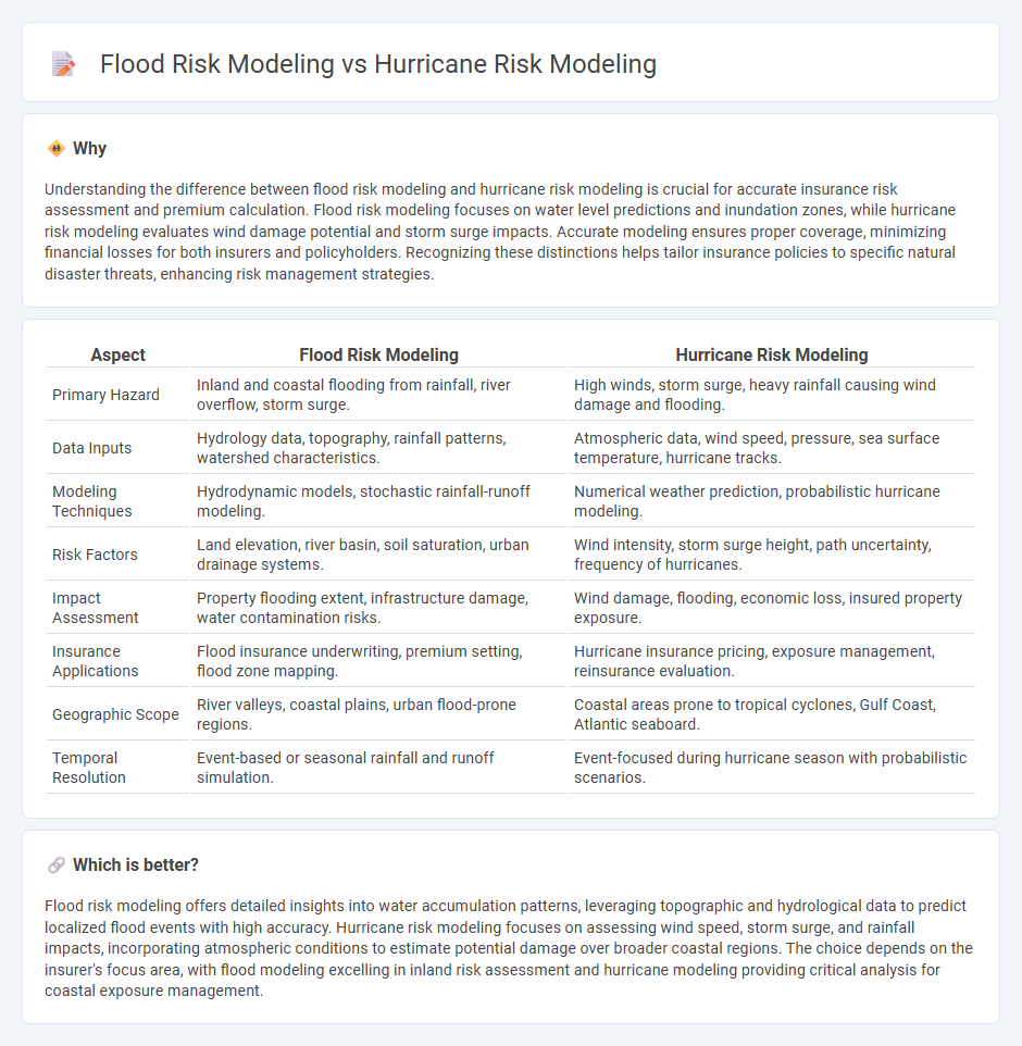
Understanding the difference between flood risk modeling and hurricane risk modeling is crucial for accurate insurance risk assessment and premium calculation. Flood risk modeling focuses on water level predictions and inundation zones, while hurricane risk modeling evaluates wind damage potential and storm surge impacts. Accurate modeling ensures proper coverage, minimizing financial losses for both insurers and policyholders. Recognizing these distinctions helps tailor insurance policies to specific natural disaster threats, enhancing risk management strategies.
Comparison Table
| Aspect | Flood Risk Modeling | Hurricane Risk Modeling |
|---|---|---|
| Primary Hazard | Inland and coastal flooding from rainfall, river overflow, storm surge. | High winds, storm surge, heavy rainfall causing wind damage and flooding. |
| Data Inputs | Hydrology data, topography, rainfall patterns, watershed characteristics. | Atmospheric data, wind speed, pressure, sea surface temperature, hurricane tracks. |
| Modeling Techniques | Hydrodynamic models, stochastic rainfall-runoff modeling. | Numerical weather prediction, probabilistic hurricane modeling. |
| Risk Factors | Land elevation, river basin, soil saturation, urban drainage systems. | Wind intensity, storm surge height, path uncertainty, frequency of hurricanes. |
| Impact Assessment | Property flooding extent, infrastructure damage, water contamination risks. | Wind damage, flooding, economic loss, insured property exposure. |
| Insurance Applications | Flood insurance underwriting, premium setting, flood zone mapping. | Hurricane insurance pricing, exposure management, reinsurance evaluation. |
| Geographic Scope | River valleys, coastal plains, urban flood-prone regions. | Coastal areas prone to tropical cyclones, Gulf Coast, Atlantic seaboard. |
| Temporal Resolution | Event-based or seasonal rainfall and runoff simulation. | Event-focused during hurricane season with probabilistic scenarios. |
Which is better?
Flood risk modeling offers detailed insights into water accumulation patterns, leveraging topographic and hydrological data to predict localized flood events with high accuracy. Hurricane risk modeling focuses on assessing wind speed, storm surge, and rainfall impacts, incorporating atmospheric conditions to estimate potential damage over broader coastal regions. The choice depends on the insurer's focus area, with flood modeling excelling in inland risk assessment and hurricane modeling providing critical analysis for coastal exposure management.
Connection
Flood risk modeling and hurricane risk modeling are interconnected through their focus on extreme weather events that cause significant water-related damage. Both models integrate hydrological data, storm surge patterns, and rainfall intensity to assess potential losses and inform insurance underwriting. Accurate hurricane risk assessments depend heavily on flood risk evaluations, as hurricanes frequently generate severe flooding impacting property damage predictions and premium calculations.
Key Terms
**Hurricane risk modeling:**
Hurricane risk modeling emphasizes the simulation of cyclonic wind patterns, storm surge, and precipitation to assess potential damage to infrastructure and communities. It integrates atmospheric data with topographical and socio-economic variables to quantify economic losses and optimize emergency response strategies. Explore more to understand the advanced methodologies and applications driving hurricane risk assessment.
Wind speed
Hurricane risk modeling emphasizes wind speed measurements, utilizing data from meteorological satellites and anemometers to predict potential structural damage and loss. Flood risk modeling integrates hydrological data such as rainfall intensity and river discharge but places less focus on wind speed as a critical factor. Explore detailed methodologies and comparative analyses of hurricane and flood risk models for advanced insights.
Storm surge
Hurricane risk modeling primarily evaluates storm surge impact by analyzing wind-driven water levels and pressure changes causing coastal flooding, while flood risk modeling considers broader hydrological factors like river overflow and rainfall accumulation. Storm surge, a critical component of hurricane risk, often results in rapid, severe inundation differing from flood patterns influenced by terrain and drainage. Explore detailed methodologies and comparative insights on storm surge impacts to enhance disaster preparedness and risk assessment.
Source and External Links
Hurricane hazard modeling - This paper discusses hurricane hazard modeling as a tool to assess risks like economic losses, wind exceedance, and flooding, using stochastic track models combined with physical environmental data to simulate hurricane life cycles and impacts along coastlines.
Hurricane Modeling and Prediction Program - NOAA/AOML - NOAA's AOML develops experimental and operational hurricane forecast models focusing on rapid intensification prediction, using statistical models such as the SHIPS-RII to estimate the probability of rapid hurricane strengthening at multiple lead times.
Hazus for Hurricane Modeling - FEMA - FEMA's Hazus software uses GIS-based risk modeling combining inventory data and wind speed with damage functions to estimate physical, economic, and social impacts of hurricanes, aiding community resilience and emergency management.