Alternative data encompasses non-traditional information sources such as social media, web traffic, and credit card transactions, providing unique insights for financial analysis beyond standard datasets. Satellite data, a subset of alternative data, offers geospatial intelligence through high-resolution imagery and remote sensing, enabling real-time monitoring of agricultural yields, infrastructure development, and commodity stocks. Explore how integrating alternative and satellite data transforms investment strategies and risk management.
Why it is important
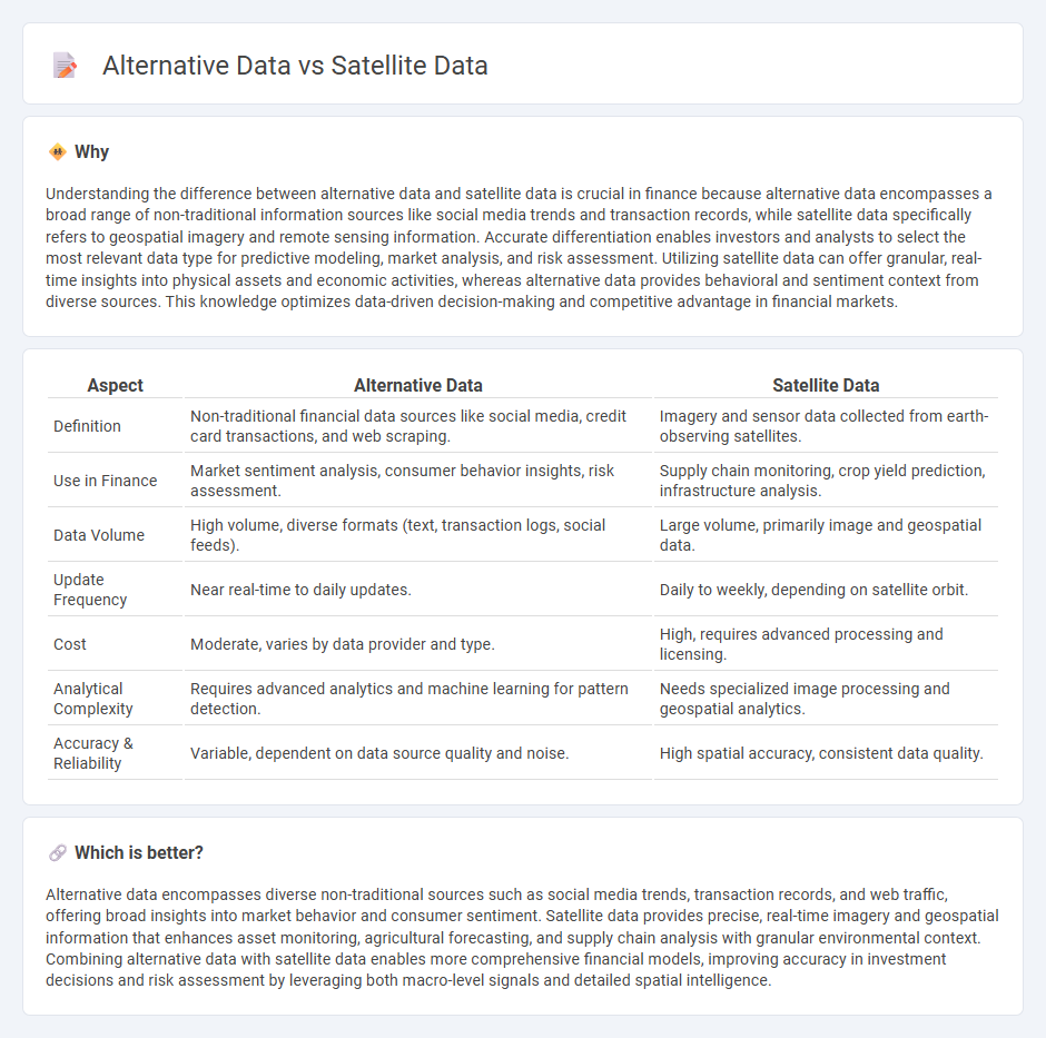
Understanding the difference between alternative data and satellite data is crucial in finance because alternative data encompasses a broad range of non-traditional information sources like social media trends and transaction records, while satellite data specifically refers to geospatial imagery and remote sensing information. Accurate differentiation enables investors and analysts to select the most relevant data type for predictive modeling, market analysis, and risk assessment. Utilizing satellite data can offer granular, real-time insights into physical assets and economic activities, whereas alternative data provides behavioral and sentiment context from diverse sources. This knowledge optimizes data-driven decision-making and competitive advantage in financial markets.
Comparison Table
| Aspect | Alternative Data | Satellite Data |
|---|---|---|
| Definition | Non-traditional financial data sources like social media, credit card transactions, and web scraping. | Imagery and sensor data collected from earth-observing satellites. |
| Use in Finance | Market sentiment analysis, consumer behavior insights, risk assessment. | Supply chain monitoring, crop yield prediction, infrastructure analysis. |
| Data Volume | High volume, diverse formats (text, transaction logs, social feeds). | Large volume, primarily image and geospatial data. |
| Update Frequency | Near real-time to daily updates. | Daily to weekly, depending on satellite orbit. |
| Cost | Moderate, varies by data provider and type. | High, requires advanced processing and licensing. |
| Analytical Complexity | Requires advanced analytics and machine learning for pattern detection. | Needs specialized image processing and geospatial analytics. |
| Accuracy & Reliability | Variable, dependent on data source quality and noise. | High spatial accuracy, consistent data quality. |
Which is better?
Alternative data encompasses diverse non-traditional sources such as social media trends, transaction records, and web traffic, offering broad insights into market behavior and consumer sentiment. Satellite data provides precise, real-time imagery and geospatial information that enhances asset monitoring, agricultural forecasting, and supply chain analysis with granular environmental context. Combining alternative data with satellite data enables more comprehensive financial models, improving accuracy in investment decisions and risk assessment by leveraging both macro-level signals and detailed spatial intelligence.
Connection
Alternative data, including satellite data, provides unique insights into financial markets by capturing real-time economic activities and environmental factors. Satellite imagery tracks asset movements, agricultural yields, and infrastructure developments, offering quantitative signals that improve investment decisions and risk assessments. Integrating satellite data with other alternative datasets enhances predictive analytics and portfolio management in finance.
Key Terms
Geospatial Analysis
Satellite data provides high-resolution imagery and real-time monitoring capabilities essential for geospatial analysis, enabling accurate land use mapping, environmental monitoring, and urban planning. Alternative data sources, such as social media feeds, mobile phone signals, and IoT sensors, complement satellite data by offering dynamic behavioral insights and ground-level context. Explore how integrating satellite and alternative data enhances the precision and scope of geospatial analytics.
Non-traditional Data Sources
Satellite data provides high-resolution, real-time imagery and geospatial insights crucial for environmental monitoring, agriculture, and urban planning, while alternative data encompasses non-traditional sources like social media feeds, sensor data, and transaction records that offer unique behavioral and market signals. Non-traditional data sources enhance predictive analytics by integrating diverse datasets beyond conventional statistics, driving innovation in industries such as finance and supply chain management. Explore how combining satellite data with alternative datasets can unlock unprecedented intelligence and decision-making capabilities.
Predictive Analytics
Satellite data offers high-resolution, real-time insights from remote sensing that enhance predictive analytics by monitoring environmental changes, crop health, or urban development. Alternative data, such as social media sentiment, transaction records, or sensor networks, provides diverse, unstructured datasets that enrich predictive models with behavioral and market trends. Explore how integrating satellite and alternative data can revolutionize your predictive analytics strategies.
Source and External Links
Satellite data | ICEYE - Provides genuine Earth Observation information for a wide range of applications including agriculture, forestry, urban development, insurance, energy, and security, with radar-based imaging that enables high-frequency coverage unaffected by weather.
Planet Labs: Satellite Imagery & Earth Data Analytics - Delivers daily high-resolution satellite imagery and analytics globally, empowering organizations to monitor change, manage operational challenges, and make data-driven decisions with unprecedented temporal and spatial detail.
NASA Worldview - Offers an interactive interface to browse full-resolution, global satellite images, with data generally available within three hours of observation, supporting real-time monitoring and analysis.