Flood risk mapping identifies areas prone to water overflow by analyzing rainfall intensity, river levels, and terrain slope, crucial for insurance underwriting and floodplain management. Sinkhole hazard mapping focuses on geological factors such as soil composition, bedrock dissolution, and groundwater movement to predict ground collapses that can cause severe property damage. Explore detailed methodologies and insurance implications of both mapping techniques to enhance risk assessment and coverage strategies.
Why it is important
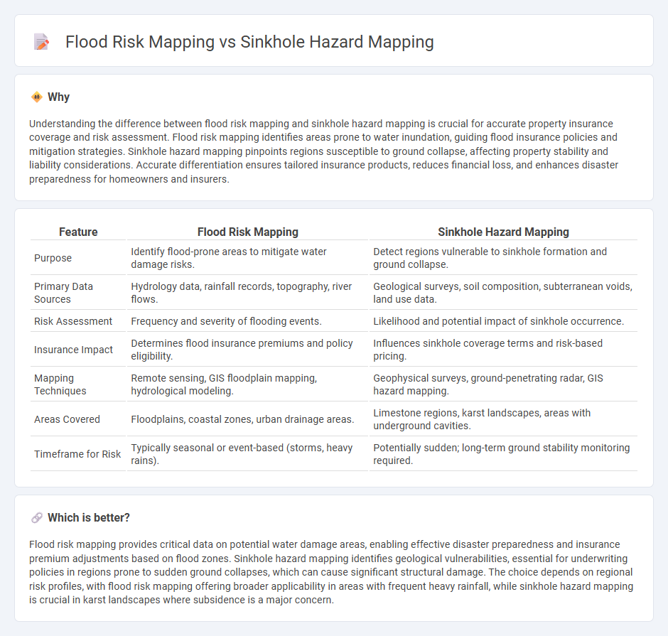
Understanding the difference between flood risk mapping and sinkhole hazard mapping is crucial for accurate property insurance coverage and risk assessment. Flood risk mapping identifies areas prone to water inundation, guiding flood insurance policies and mitigation strategies. Sinkhole hazard mapping pinpoints regions susceptible to ground collapse, affecting property stability and liability considerations. Accurate differentiation ensures tailored insurance products, reduces financial loss, and enhances disaster preparedness for homeowners and insurers.
Comparison Table
| Feature | Flood Risk Mapping | Sinkhole Hazard Mapping |
|---|---|---|
| Purpose | Identify flood-prone areas to mitigate water damage risks. | Detect regions vulnerable to sinkhole formation and ground collapse. |
| Primary Data Sources | Hydrology data, rainfall records, topography, river flows. | Geological surveys, soil composition, subterranean voids, land use data. |
| Risk Assessment | Frequency and severity of flooding events. | Likelihood and potential impact of sinkhole occurrence. |
| Insurance Impact | Determines flood insurance premiums and policy eligibility. | Influences sinkhole coverage terms and risk-based pricing. |
| Mapping Techniques | Remote sensing, GIS floodplain mapping, hydrological modeling. | Geophysical surveys, ground-penetrating radar, GIS hazard mapping. |
| Areas Covered | Floodplains, coastal zones, urban drainage areas. | Limestone regions, karst landscapes, areas with underground cavities. |
| Timeframe for Risk | Typically seasonal or event-based (storms, heavy rains). | Potentially sudden; long-term ground stability monitoring required. |
Which is better?
Flood risk mapping provides critical data on potential water damage areas, enabling effective disaster preparedness and insurance premium adjustments based on flood zones. Sinkhole hazard mapping identifies geological vulnerabilities, essential for underwriting policies in regions prone to sudden ground collapses, which can cause significant structural damage. The choice depends on regional risk profiles, with flood risk mapping offering broader applicability in areas with frequent heavy rainfall, while sinkhole hazard mapping is crucial in karst landscapes where subsidence is a major concern.
Connection
Flood risk mapping and sinkhole hazard mapping both assess geospatial vulnerabilities that impact insurance underwriting and risk management. Integrated analysis of hydrological data and geological formations enhances predictive accuracy by identifying overlapping zones prone to water-induced soil erosion and subterranean collapses. Insurers utilize these combined hazard maps to tailor coverage policies and set premiums that reflect the compounded risk of flood-related sinkhole damage.
Key Terms
Hazard Zonation
Sinkhole hazard mapping involves identifying vulnerable karst terrains where subsurface voids may collapse, causing sudden land depressions, whereas flood risk mapping assesses areas prone to water overflow due to rainfall or river discharge exceeding capacity. Both hazard zonation methods utilize geographic information systems (GIS) for spatial analysis, but sinkhole mapping emphasizes geological and hydrogeological factors, while flood mapping prioritizes hydrological data and precipitation patterns. Explore detailed methodologies and case studies to understand effective hazard zonation strategies for disaster risk reduction.
Vulnerability Assessment
Sinkhole hazard mapping identifies areas susceptible to ground collapse by evaluating geological formations, soil types, and human activities, while flood risk mapping analyzes hydrological data, rainfall patterns, and topography to predict flood-prone zones. Vulnerability assessment in sinkhole mapping emphasizes infrastructure stability and population exposure to subsidence, whereas flood risk vulnerability focuses on community preparedness, evacuation routes, and economic impact. Explore detailed methodologies and case studies to better understand how vulnerability assessments shape disaster mitigation strategies.
Loss Modeling
Sinkhole hazard mapping centers on identifying subsidence-prone areas by integrating geological, hydrological, and soil data to predict potential ground collapse, crucial for infrastructure resilience and property insurance loss modeling. Flood risk mapping employs hydrological models, rainfall patterns, and topography to estimate flood extent and depth, informing damage and economic loss assessments in urban and rural zones. Explore detailed methodologies and comparative effectiveness of both approaches to enhance disaster risk management and loss prevention.
Source and External Links
Sinkhole risk mapping and early warning: the case of Camaiore (Italy) - Sinkhole hazard mapping can be conducted in a GIS environment by integrating layers of susceptibility, vulnerability, and risk elements using weighted factors such as seismicity, limestone bedrock presence, fault proximity, underground cavity indicators, and ground displacement data from interferometric radar measurements to generate a risk zonation map.
Sinkhole Susceptibility Hazard Mapping Using Analytical Hierarchy Process - Sinkhole susceptibility in Kuwait was mapped by combining Analytical Hierarchy Process (AHP) and GIS, selecting criteria like water table depth, fault proximity, earthquake zones, soil properties, and bedrock characteristics, resulting in a classified hazard map to support engineering and emergency planning.
Geospatial Modeling for Sinkholes Hazard Map Based on GIS & RS - A sinkhole hazard map can be developed using GIS-based weighted overlay modeling of hazard factors such as slope gradient, fault distribution, urban development, and prior sinkhole occurrence, assigning weights to each factor and classifying hazard levels for predictive and risk assessment purposes.