Flood risk mapping involves identifying areas vulnerable to floodwaters by analyzing topography, rainfall patterns, and historical flood data, crucial for accurate insurance underwriting. Hurricane wind analysis assesses potential wind damage by examining storm intensity, wind speeds, and structural vulnerabilities to determine risk exposure. Explore further to understand how these assessments impact insurance policies and claims management.
Why it is important
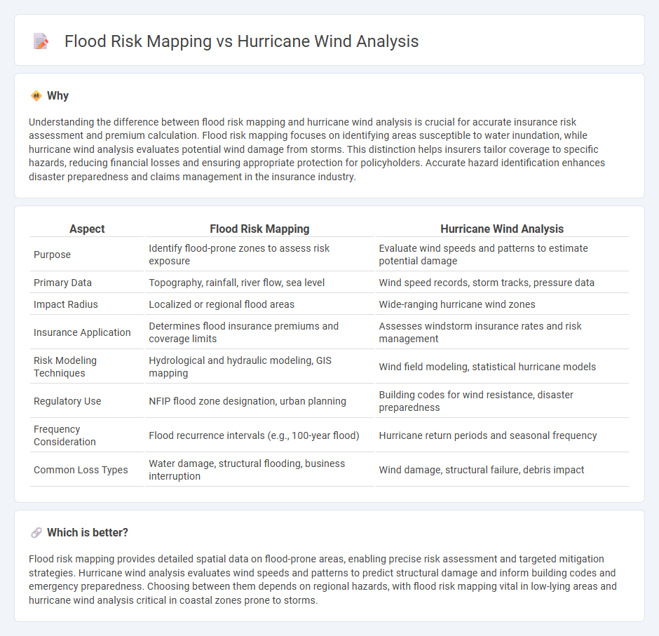
Understanding the difference between flood risk mapping and hurricane wind analysis is crucial for accurate insurance risk assessment and premium calculation. Flood risk mapping focuses on identifying areas susceptible to water inundation, while hurricane wind analysis evaluates potential wind damage from storms. This distinction helps insurers tailor coverage to specific hazards, reducing financial losses and ensuring appropriate protection for policyholders. Accurate hazard identification enhances disaster preparedness and claims management in the insurance industry.
Comparison Table
| Aspect | Flood Risk Mapping | Hurricane Wind Analysis |
|---|---|---|
| Purpose | Identify flood-prone zones to assess risk exposure | Evaluate wind speeds and patterns to estimate potential damage |
| Primary Data | Topography, rainfall, river flow, sea level | Wind speed records, storm tracks, pressure data |
| Impact Radius | Localized or regional flood areas | Wide-ranging hurricane wind zones |
| Insurance Application | Determines flood insurance premiums and coverage limits | Assesses windstorm insurance rates and risk management |
| Risk Modeling Techniques | Hydrological and hydraulic modeling, GIS mapping | Wind field modeling, statistical hurricane models |
| Regulatory Use | NFIP flood zone designation, urban planning | Building codes for wind resistance, disaster preparedness |
| Frequency Consideration | Flood recurrence intervals (e.g., 100-year flood) | Hurricane return periods and seasonal frequency |
| Common Loss Types | Water damage, structural flooding, business interruption | Wind damage, structural failure, debris impact |
Which is better?
Flood risk mapping provides detailed spatial data on flood-prone areas, enabling precise risk assessment and targeted mitigation strategies. Hurricane wind analysis evaluates wind speeds and patterns to predict structural damage and inform building codes and emergency preparedness. Choosing between them depends on regional hazards, with flood risk mapping vital in low-lying areas and hurricane wind analysis critical in coastal zones prone to storms.
Connection
Flood risk mapping and hurricane wind analysis are interconnected components of comprehensive disaster risk assessment, providing critical data to insurance companies for evaluating potential damages. Flood risk mapping identifies areas prone to inundation, while hurricane wind analysis assesses structural vulnerabilities to high-speed winds, both influencing policy premiums and coverage limits. Integrating these analyses enables insurers to accurately model catastrophe scenarios, optimize risk management strategies, and offer tailored insurance solutions for flood and hurricane-prone regions.
Key Terms
**Hurricane wind analysis:**
Hurricane wind analysis involves assessing wind speed patterns, gust intensity, and directional changes during storms to predict damage potential and enhance building codes. It incorporates data from Doppler radar, anemometers, and satellite imagery to model wind behavior and structural impacts accurately. Explore detailed methodologies and tools in hurricane wind analysis to improve disaster preparedness and resilience.
Wind speed zones
Hurricane wind speed zones are classified based on sustained wind velocities, which directly impact structural design standards and emergency preparedness strategies in coastal regions. Flood risk mapping prioritizes hydrological data and topography to identify areas susceptible to inundation, but lacks the granularity required for assessing wind-related damage potential. Explore comprehensive risk assessment methods integrating both models for enhanced disaster resilience planning.
Building vulnerability
Hurricane wind analysis evaluates the impact of high-velocity winds on building structures, focusing on materials, design standards, and potential for structural failure. Flood risk mapping identifies areas susceptible to water inundation, analyzing ground elevation, drainage systems, and floodplain dynamics to assess vulnerability. Explore detailed methodologies and risk mitigation strategies to better protect buildings against these natural hazards.
Source and External Links
Hurricane Ike - Wind Analysis - National Weather Service - Detailed analysis of Hurricane Ike's wind speeds shows maximum surface winds of 73-85 mph after adjusting radar data taken 1000 to 3000 feet above ground level with a reduction factor to estimate surface winds accurately.
HRD real-time hurricane wind analysis system - Poststorm analyses combine surface and radar data to validate wind distribution models, showing peak surface winds often greater over the ocean and along the coastline, with quality-controlled observations forming the basis of accurate wind field mapping.
Saffir-Simpson Hurricane Wind Scale - The scale categorizes hurricanes based on maximum sustained wind speeds from 74 mph (Category 1) up to 157+ mph (Category 5), relating wind intensity directly to expected damage types.