Spatial computing integrates real-time data processing, sensor technologies, and augmented reality to create immersive environments that interact dynamically with the physical world, while Geographic Information Systems (GIS) focus on capturing, storing, analyzing, and visualizing geospatial data to support decision-making and mapping. Spatial computing leverages advancements in AI and IoT to enhance situational awareness and user interaction beyond traditional mapping capabilities found in GIS. Explore the evolving synergy and distinct roles of spatial computing and GIS in transforming technology landscapes.
Why it is important
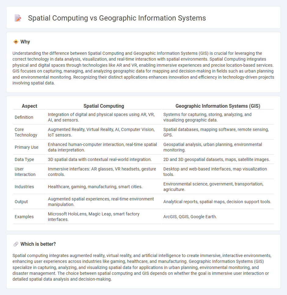
Understanding the difference between Spatial Computing and Geographic Information Systems (GIS) is crucial for leveraging the correct technology in data analysis, visualization, and real-time interaction with spatial environments. Spatial Computing integrates physical and digital spaces through technologies like AR and VR, enabling immersive experiences and precise location-based services. GIS focuses on capturing, managing, and analyzing geographic data for mapping and decision-making in fields such as urban planning and environmental monitoring. Recognizing their distinct applications enhances innovation and efficiency in technology-driven projects involving spatial data.
Comparison Table
| Aspect | Spatial Computing | Geographic Information Systems (GIS) |
|---|---|---|
| Definition | Integration of digital and physical spaces using AR, VR, AI, and sensors. | Systems for capturing, storing, analyzing, and visualizing geographic data. |
| Core Technology | Augmented Reality, Virtual Reality, AI, Computer Vision, IoT sensors. | Spatial databases, mapping software, remote sensing, GPS. |
| Primary Use | Enhanced human-computer interaction, real-time spatial data interpretation. | Geospatial analysis, urban planning, environmental monitoring. |
| Data Type | 3D spatial data with contextual real-world integration. | 2D and 3D geospatial datasets, maps, satellite images. |
| User Interaction | Immersive interfaces: AR glasses, VR headsets, gesture controls. | Desktop and web-based interfaces, map visualization tools. |
| Industries | Healthcare, gaming, manufacturing, smart cities. | Environmental science, government, transportation, agriculture. |
| Output | Augmented spatial experiences, real-time environment manipulation. | Analytical reports, spatial maps, decision support tools. |
| Examples | Microsoft HoloLens, Magic Leap, smart factory interfaces. | ArcGIS, QGIS, Google Earth. |
Which is better?
Spatial computing integrates augmented reality, virtual reality, and artificial intelligence to create immersive, interactive environments, enhancing user experiences across industries like gaming, healthcare, and manufacturing. Geographic Information Systems (GIS) specialize in capturing, analyzing, and visualizing spatial data for applications in urban planning, environmental monitoring, and disaster management. The choice between spatial computing and GIS depends on whether the goal is immersive user interaction or detailed spatial data analysis and decision-making.
Connection
Spatial computing integrates geographic information systems (GIS) by leveraging advanced technologies such as 3D mapping, augmented reality (AR), and real-time location data to analyze and visualize spatial relationships within geographic contexts. GIS provides the foundational geospatial data and analytical tools that enable spatial computing applications to interpret and interact with physical environments dynamically. Together, they drive innovations in smart cities, autonomous navigation, and environmental monitoring through enhanced spatial awareness and data-driven decision-making.
Key Terms
GIS (Geographic Information Systems)
Geographic Information Systems (GIS) are specialized tools designed for capturing, analyzing, and visualizing geospatial data to support mapping, spatial analysis, and decision-making processes. Unlike broader spatial computing that encompasses various technologies like augmented reality and 3D mapping, GIS emphasizes data accuracy, layering, and integration for applications in urban planning, environmental monitoring, and resource management. Explore deeper to understand how GIS transforms spatial data into actionable insights for diverse industries.
Geospatial Data
Geographic Information Systems (GIS) specialize in capturing, storing, analyzing, and managing geospatial data for mapping and spatial analysis, enabling precise visualization of geographic patterns. Spatial computing integrates geospatial data with advanced technologies such as augmented reality, machine learning, and sensor networks to deliver interactive, real-time spatial experiences across physical and digital environments. Explore deeper insights into how GIS and spatial computing transform geospatial data applications by diving into the latest technological advancements.
Spatial Analytics
Spatial Analytics in Geographic Information Systems (GIS) involves processing and analyzing geospatial data to identify patterns, relationships, and trends across geographic locations using tools like ArcGIS and QGIS. Spatial Computing expands on GIS by integrating real-time data, augmented reality, and sensor networks to enable dynamic spatial interactions and enhanced decision-making. Explore the evolving capabilities of Spatial Analytics within Spatial Computing to unlock deeper insights.
Source and External Links
Geographic Information System - A geographic information system (GIS) combines hardware and software to store, manage, analyze, and visualize geographic data, integrating spatial and attribute information.
Geographic Information System (GIS) - GIS is a computer-based framework for organizing and analyzing spatial data, enhancing understanding of the Earth's surface and features like the ocean.
WHAT IS GIS? - GIS technology creates, manages, analyzes, and maps various types of data by integrating it with location information, providing insights for decision-making.