Flood risk modeling focuses on analyzing hydrological data, historical rainfall patterns, and topography to predict inundation zones and potential property damage, while wildfire risk modeling incorporates vegetation types, weather conditions, and ignition sources to estimate fire spread and intensity. Insurers use these models to set premiums, manage claims, and implement risk mitigation strategies tailored to each natural hazard's unique characteristics. Discover how advanced modeling techniques are transforming insurance underwriting and disaster preparedness.
Why it is important
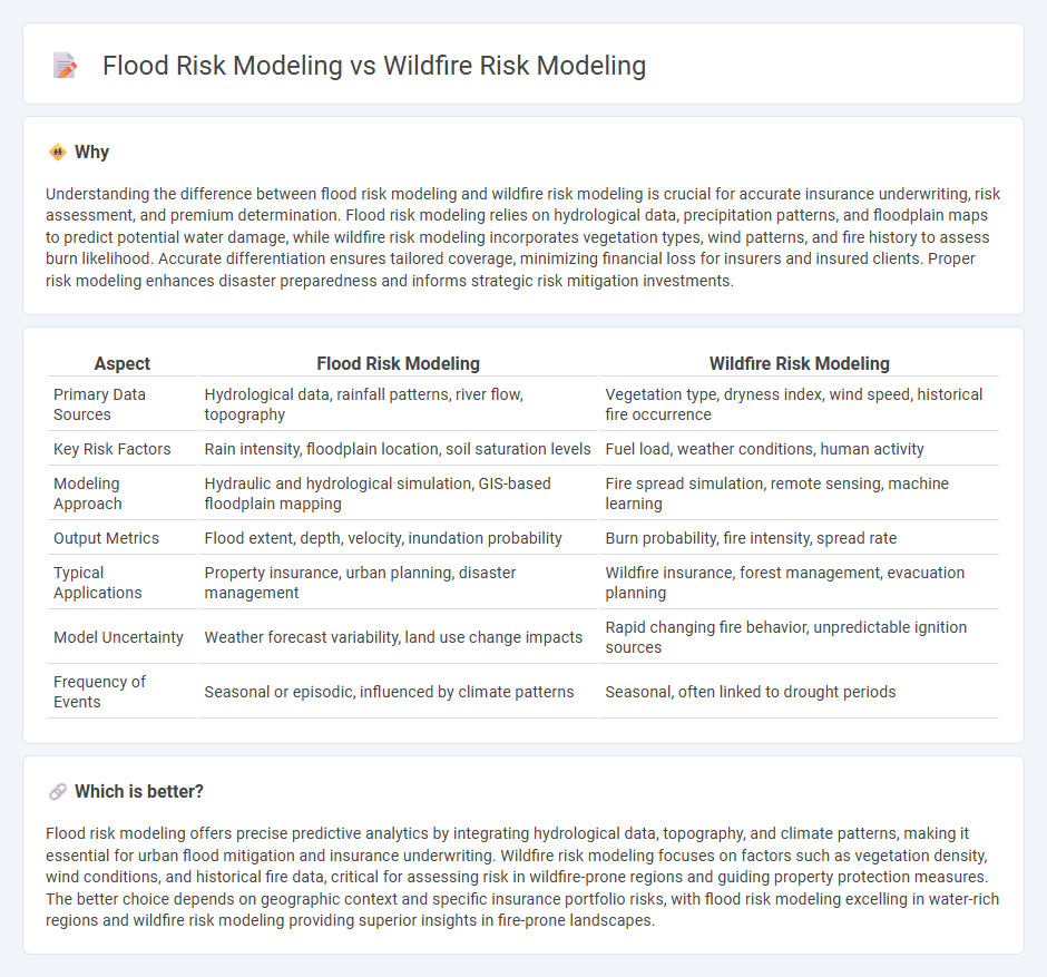
Understanding the difference between flood risk modeling and wildfire risk modeling is crucial for accurate insurance underwriting, risk assessment, and premium determination. Flood risk modeling relies on hydrological data, precipitation patterns, and floodplain maps to predict potential water damage, while wildfire risk modeling incorporates vegetation types, wind patterns, and fire history to assess burn likelihood. Accurate differentiation ensures tailored coverage, minimizing financial loss for insurers and insured clients. Proper risk modeling enhances disaster preparedness and informs strategic risk mitigation investments.
Comparison Table
| Aspect | Flood Risk Modeling | Wildfire Risk Modeling |
|---|---|---|
| Primary Data Sources | Hydrological data, rainfall patterns, river flow, topography | Vegetation type, dryness index, wind speed, historical fire occurrence |
| Key Risk Factors | Rain intensity, floodplain location, soil saturation levels | Fuel load, weather conditions, human activity |
| Modeling Approach | Hydraulic and hydrological simulation, GIS-based floodplain mapping | Fire spread simulation, remote sensing, machine learning |
| Output Metrics | Flood extent, depth, velocity, inundation probability | Burn probability, fire intensity, spread rate |
| Typical Applications | Property insurance, urban planning, disaster management | Wildfire insurance, forest management, evacuation planning |
| Model Uncertainty | Weather forecast variability, land use change impacts | Rapid changing fire behavior, unpredictable ignition sources |
| Frequency of Events | Seasonal or episodic, influenced by climate patterns | Seasonal, often linked to drought periods |
Which is better?
Flood risk modeling offers precise predictive analytics by integrating hydrological data, topography, and climate patterns, making it essential for urban flood mitigation and insurance underwriting. Wildfire risk modeling focuses on factors such as vegetation density, wind conditions, and historical fire data, critical for assessing risk in wildfire-prone regions and guiding property protection measures. The better choice depends on geographic context and specific insurance portfolio risks, with flood risk modeling excelling in water-rich regions and wildfire risk modeling providing superior insights in fire-prone landscapes.
Connection
Flood risk modeling and wildfire risk modeling both utilize geospatial data and climate variables to predict hazard exposure and potential damage in vulnerable areas. These models incorporate hydraulic simulations, vegetation patterns, soil moisture levels, historical weather data, and topography to assess risks and inform mitigation strategies. Integrating flood and wildfire risk modeling supports comprehensive disaster management, improves resource allocation, and enhances community resilience against multiple natural hazards.
Key Terms
**Wildfire risk modeling:**
Wildfire risk modeling integrates satellite imagery, vegetation data, and weather patterns to predict fire-prone areas with high accuracy. Advanced machine learning algorithms analyze historical fire incidents, fuel moisture levels, and wind conditions to forecast wildfire spread and intensity. Explore our detailed insights to understand how cutting-edge wildfire risk models enhance prevention and mitigation strategies.
Fuel load
Fuel load plays a crucial role in wildfire risk modeling as it directly impacts fire behavior, intensity, and spread by providing combustible material. In contrast, flood risk modeling emphasizes hydrological factors such as rainfall, soil saturation, and topography, with fuel load being largely irrelevant. Explore detailed comparisons and methodologies in risk modeling to better understand these distinct environmental hazards.
Fire spread simulators
Fire spread simulators are crucial tools in wildfire risk modeling, enabling precise prediction of fire behavior based on factors such as fuel type, weather conditions, and topography. In contrast, flood risk modeling relies heavily on hydrological and hydraulic models to simulate water flow and inundation extents. Explore the latest advancements in fire spread simulation technology to enhance wildfire management strategies.
Source and External Links
Wildfire Risk Modeling - Moody's - Moody's offers advanced wildfire risk models and analytics to assess exposure and build resilience across North America.
Wildfire Risk Model -- ZestyAI - ZestyAI's Z-FIRE provides individualized wildfire risk scores for properties using AI and extensive loss data.
Fire Risk Modelling - FLARE Wildfire Research - FLARE provides robust fire risk modeling to guide decision-making and management, focusing on local and landscape scales.