Flood risk modeling relies on hydrological data, topography, and climate patterns to predict potential water damage, while earthquake risk modeling focuses on seismic activity, fault lines, and ground motion analysis to estimate structural impact. Both approaches use probabilistic risk assessments to guide insurance underwriting and loss prevention strategies. Discover more about how these specialized models drive accurate insurance pricing and risk management.
Why it is important
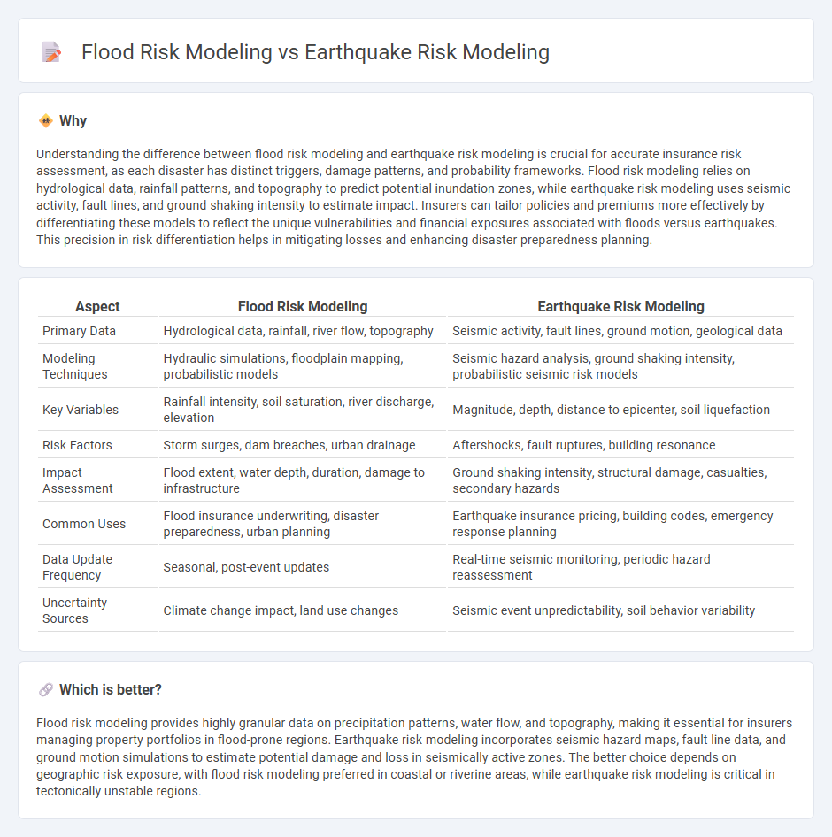
Understanding the difference between flood risk modeling and earthquake risk modeling is crucial for accurate insurance risk assessment, as each disaster has distinct triggers, damage patterns, and probability frameworks. Flood risk modeling relies on hydrological data, rainfall patterns, and topography to predict potential inundation zones, while earthquake risk modeling uses seismic activity, fault lines, and ground shaking intensity to estimate impact. Insurers can tailor policies and premiums more effectively by differentiating these models to reflect the unique vulnerabilities and financial exposures associated with floods versus earthquakes. This precision in risk differentiation helps in mitigating losses and enhancing disaster preparedness planning.
Comparison Table
| Aspect | Flood Risk Modeling | Earthquake Risk Modeling |
|---|---|---|
| Primary Data | Hydrological data, rainfall, river flow, topography | Seismic activity, fault lines, ground motion, geological data |
| Modeling Techniques | Hydraulic simulations, floodplain mapping, probabilistic models | Seismic hazard analysis, ground shaking intensity, probabilistic seismic risk models |
| Key Variables | Rainfall intensity, soil saturation, river discharge, elevation | Magnitude, depth, distance to epicenter, soil liquefaction |
| Risk Factors | Storm surges, dam breaches, urban drainage | Aftershocks, fault ruptures, building resonance |
| Impact Assessment | Flood extent, water depth, duration, damage to infrastructure | Ground shaking intensity, structural damage, casualties, secondary hazards |
| Common Uses | Flood insurance underwriting, disaster preparedness, urban planning | Earthquake insurance pricing, building codes, emergency response planning |
| Data Update Frequency | Seasonal, post-event updates | Real-time seismic monitoring, periodic hazard reassessment |
| Uncertainty Sources | Climate change impact, land use changes | Seismic event unpredictability, soil behavior variability |
Which is better?
Flood risk modeling provides highly granular data on precipitation patterns, water flow, and topography, making it essential for insurers managing property portfolios in flood-prone regions. Earthquake risk modeling incorporates seismic hazard maps, fault line data, and ground motion simulations to estimate potential damage and loss in seismically active zones. The better choice depends on geographic risk exposure, with flood risk modeling preferred in coastal or riverine areas, while earthquake risk modeling is critical in tectonically unstable regions.
Connection
Flood risk modeling and earthquake risk modeling are connected through their reliance on geospatial data and probabilistic hazard assessment techniques to predict potential damage and inform risk mitigation strategies. Both models incorporate environmental variables, historical event records, and vulnerability analysis to estimate the severity and frequency of natural disasters. Integrating these models enhances comprehensive disaster risk management by addressing multi-hazard scenarios that can simultaneously impact infrastructure and communities.
Key Terms
**Earthquake risk modeling:**
Earthquake risk modeling involves assessing seismic hazards by analyzing fault lines, ground shaking potential, and soil liquefaction to estimate potential damage to structures and populations. It utilizes historical earthquake data, seismic intensity measures, and geospatial analysis to predict risk zones and inform building codes and emergency preparedness. Explore advanced earthquake risk modeling techniques and tools to enhance disaster resilience and mitigation strategies.
Seismic hazard
Seismic hazard assessment evaluates fault lines, ground shaking intensity, and earthquake recurrence intervals to predict earthquake risk, while flood risk modeling centers on hydrological patterns, rainfall data, and river overflow probabilities. Earthquake risk modeling uses seismic hazard maps and probabilistic seismic hazard analysis (PSHA) to quantify shaking hazards, critical for urban planning in seismic zones. Explore detailed methodologies and case studies to better understand seismic hazard impacts on risk modeling.
Ground motion attenuation
Earthquake risk modeling emphasizes ground motion attenuation to predict seismic wave intensity decay with distance, crucial for assessing potential structural damage and hazard levels. Flood risk modeling, in contrast, concentrates on hydraulic dynamics and terrain hydrography rather than ground motion, relying on rainfall patterns, river discharge, and topographical data to estimate water flow and inundation zones. Explore detailed methodologies and advancements in both models to enhance disaster preparedness and mitigation strategies.
Source and External Links
DRF Analytics 101 Series - Note 2b Earthquake Modeling - Provides a detailed framework for earthquake risk modeling combining hazard, exposure, vulnerability, and loss modules to probabilistically estimate earthquake losses including secondary effects like tsunamis, with applications in parametric insurance.
RMS Earthquake Models - Offers advanced earthquake risk models incorporating ground shaking, liquefaction, landslides, fires, and tsunamis, using high-resolution simulations and scientific data for comprehensive loss assessment and financial risk management.
The AIR U.S. Earthquake Model - A longstanding and frequently updated earthquake risk model providing detailed hazard, vulnerability, and loss assessments including secondary effects such as fire following, liquefaction, and sprinkler leakage, widely used for catastrophe bonds and risk transfer.