Digital twins create precise 3D models of real estate properties using real-time data, enhancing property visualization and management. Drone mapping captures high-resolution aerial images and geospatial data, enabling accurate site surveys and progress monitoring. Discover how these innovative technologies transform real estate workflows for better decision-making and efficiency.
Why it is important
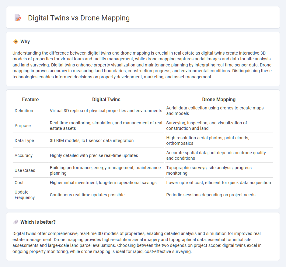
Understanding the difference between digital twins and drone mapping is crucial in real estate as digital twins create interactive 3D models of properties for virtual tours and facility management, while drone mapping captures aerial images and data for site analysis and land surveying. Digital twins enhance property visualization and maintenance planning by integrating real-time sensor data. Drone mapping improves accuracy in measuring land boundaries, construction progress, and environmental conditions. Distinguishing these technologies enables informed decisions on property development, marketing, and asset management.
Comparison Table
| Feature | Digital Twins | Drone Mapping |
|---|---|---|
| Definition | Virtual 3D replica of physical properties and environments | Aerial data collection using drones to create maps and models |
| Purpose | Real-time monitoring, simulation, and management of real estate assets | Surveying, inspection, and visualization of construction and land |
| Data Type | 3D BIM models, IoT sensor data integration | High-resolution aerial photos, point clouds, orthomosaics |
| Accuracy | Highly detailed with precise real-time updates | Accurate spatial data, but depends on drone quality and conditions |
| Use Cases | Building performance, energy management, maintenance planning | Topographic surveys, site analysis, progress monitoring |
| Cost | Higher initial investment, long-term operational savings | Lower upfront cost, efficient for quick data acquisition |
| Update Frequency | Continuous real-time updates possible | Periodic sessions depending on project needs |
Which is better?
Digital twins offer comprehensive, real-time 3D models of properties, enabling detailed analysis and simulation for improved real estate management. Drone mapping provides high-resolution aerial imagery and topographical data, essential for initial site assessments and large-scale land parcel evaluations. Choosing between the two depends on project scope: digital twins excel in ongoing property monitoring, while drone mapping is ideal for rapid, cost-effective surveying.
Connection
Digital twins leverage drone mapping data to create highly accurate, real-time 3D models of real estate properties, enhancing planning and management efficiency. Drone-captured imagery and geospatial information feed into digital twin platforms, enabling precise monitoring of construction progress and property conditions. This integration streamlines asset management by providing detailed virtual representations for decision-making and predictive analytics.
Key Terms
Aerial Surveying
Drone mapping leverages high-resolution aerial imagery and LiDAR data to create precise, georeferenced 2D maps and 3D models for topographic surveys and construction monitoring. Digital twins integrate aerial survey data with real-time sensor inputs and BIM to simulate dynamic, interactive virtual replicas of physical assets, enhancing facility management and predictive maintenance. Explore how combining these technologies revolutionizes accuracy and decision-making in aerial surveying.
3D Modeling
Drone mapping captures high-resolution aerial data to create accurate 3D models of physical environments, offering rapid and detailed spatial analysis. Digital twins integrate these 3D models with real-time data and simulations to optimize performance and predict outcomes in various industries. Discover how combining drone mapping and digital twins revolutionizes 3D modeling for smarter decision-making.
Georeferencing
Drone mapping captures high-resolution aerial imagery with precise georeferencing through GPS and ground control points, enabling accurate spatial data collection over large areas. Digital twins integrate georeferenced drone data into dynamic 3D models that reflect real-time changes and provide actionable insights for infrastructure management and urban planning. Explore how combining drone mapping's geospatial accuracy with digital twin technology revolutionizes georeferencing applications in diverse industries.
Source and External Links
Drone Mapping Guide - This guide provides an overview of drone mapping, including mission planning, media capture, and data processing to create detailed maps and models.
A Guide to Drone Mapping - Offers insights into drone mapping software, use cases, and terminology, highlighting the technology's role in surveying and commercial applications.
Drone Mapping - Allows users to create detailed orthophotos and aerial imagery using drones, emphasizing the importance of overlap and nadir images for quality map creation.